Manihiki Airport Improvement Project
The Manihiki Airport upgrade has been a long-term priority for the Cook Islands Government, first identified in the 2007 Preventative Infrastructure Master Plan (PIMP). A 2013 feasibility study for Cook Islands airports outlined the scope, costs, and benefits of upgrading the airport, identifying Manihiki as a potential hub for the Northern Group. The study highlighted opportunities for larger aircraft operations—such as the Saab SF340 and ATR 72—to boost tourism, reduce airfares, and strengthen local connectivity.
Following COVID-19, Air Rarotonga and Tourism Cook Islands continue to support the upgrade, noting that improved facilities would enable larger aircraft operations, lower average fares, and drive sustainable tourism and economic growth.
The 2015 National Infrastructure Investment Plan reaffirmed the strong demand for Saab aircraft operations in the Northern Group, requiring at least two suitable airports for alternate landing options. Air Rarotonga advised that it would operate the Saab into an upgraded Manihiki airstrip, with Penrhyn as the alternate. The Manihiki Airport has remained a government priority through the NSDP 2016–2020 and beyond.
In 2019, the Ministry of Transport conducted an Aeronautical Study that recommended key safety and design improvements, which now form the basis of this project. Infrastructure Cook Islands (ICI) is leading the delivery of the project and will continue to collaborate with relevant agencies through Memorandums of Understanding (MOUs).
The goal of this project is to provide safe, reliable, and resilient airport infrastructure that strengthens connectivity, supports economic opportunities, and enhances the wellbeing of the Pa Enua communities.

Read the legal documentation for the project:
Scope and Location
This project involves the rehabilitation and construction of the Manihiki airport runway to provide safer, affordable access to the residents and visitors of Manihiki whilst ensuring climate resilience reducing overwash onto the newly constructed runway.- The works also allow for a temporary ship landing site to provide access from shipping vessels to land plant, machinery and materials to complete the construction of the runway. It also includes the realignment and reconstruction of a 195m stretch of an adjacent local road. All work elements needed to access the site and undertake this work have been allowed for.
Temporary Sea Vessels Landing Site
A sheetpiled platform connecting to a 40m sheetpile lined causeway, infilled with beach gravel and concrete blocks will be constructed on the edge of the coral shelf tied into the remaining 120m causeway made up of composite mats with sand bags to fill coral pools on the reef flat making the mats trafficable during low tide.
The composite mats are buoyant and are trafficable up to loads of 20Tn allowing land access during high tide. The causeway will be installed adjacent to the Tukao Harbor.
ICI prefers the offloading of plant and materials during low tide periods as the risk of damage to plant is greatly reduced. The option to offload plant and materials during high tide periods was required to ensure program milestones are met.
An overview of the temporary landing site is provided in Figure 1 below and figure shows a typical cross section.
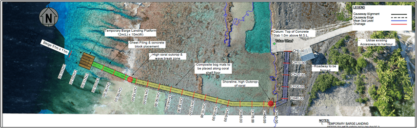
Figure 1. Tukao Temporary Barge Landing Site Plan
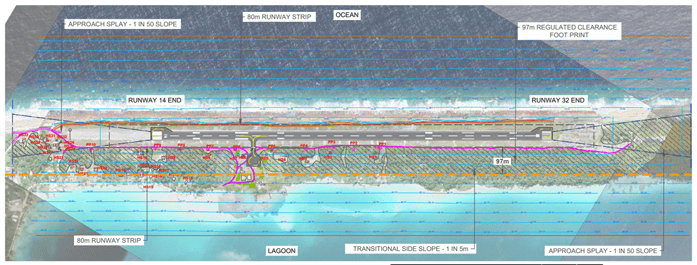
Figure 2. Clearance Site Plan
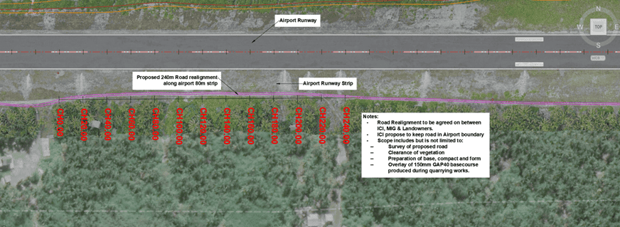
Figure 3. Road Realignment Site Plan